|
Errors concerning Sol system bodies
|
|
| FastFourierTransform | Date: Saturday, 04.04.2015, 00:16 | Message # 31 |
 Pioneer
Group: Local Moderators
 Spain
Spain
Messages: 542
Status: Offline
| Maybe this is of your interest my fellow vestalians: http://vestatrek.jpl.nasa.gov/
You can see there all kind of emmisions, topographic and geological maps and real color maps of Vesta. 
|
| |
| |
| 36ophiuchi | Date: Sunday, 05.04.2015, 09:10 | Message # 32 |
|
Space Tourist
Group: Users
 Pirate
Messages: 26
Status: Offline
| Quote FastFourierTransform (  ) Maybe this is of your interest my fellow vestalians: http://vestatrek.jpl.nasa.gov/ You can see there all kind of emmisions, topographic and geological maps and real color maps of Vesta.
I'm familiar with this site, thanks for posting it here! It is interesting to note, that the same artifacts I've encountered also seem to be present here. I've removed those and then some. We shall find out what SpaceEngineer is going to make of it 
Edited by 36ophiuchi - Sunday, 05.04.2015, 09:10 |
| |
| |
| JohnVV | Date: Monday, 13.04.2015, 20:46 | Message # 33 |
|
Space Tourist
Group: Users
 United States
Messages: 36
Status: Offline
| for those interested the 2013 true color Vesta map is here
on the dawn data site
http://dawndata.igpp.ucla.edu/tw.jsp?....lor_DLR
( the .cub files are for the GIS program ISIS3 )Added (13.04.2015, 20:46)
---------------------------------------------
Quote
I am surprised by the seam at 0 degrees... I just noticed that the DTM contains a black frame a few pixels-wide....
the PDS *.img data for DEM's normally have a 1 px ( NULL DATA ) border
this helps for interpolating the data into various GIS software programs for remapping
|
| |
| |
| 36ophiuchi | Date: Tuesday, 14.04.2015, 16:35 | Message # 34 |
|
Space Tourist
Group: Users
 Pirate
Messages: 26
Status: Offline
| Quote JohnVV (  ) for those interested the 2013 true color Vesta map is here on the dawn data site http://dawndata.igpp.ucla.edu/tw.jsp?....lor_DLR ( the .cub files are for the GIS program ISIS3 ) Added (13.04.2015, 20:46) --------------------------------------------- the PDS *.img data for DEM's normally have a 1 px ( NULL DATA ) border this helps for interpolating the data into various GIS software programs for remapping
I've uploaded a corrected Vesta DTM for SpaceEngineer some 2 weeks ago, however he has yet to reply back and tell me as to whether it works better now...
I guess I never realized the NULL DATA border so far... ISIS3 automatically removes that frame, and/or ArcGIS simply does not display NO DATA frames unless you specifically want it.
|
| |
| |
| SpaceEngineer | Date: Wednesday, 15.04.2015, 09:28 | Message # 35 |
 Author of Space Engine
Group: Administrators
 Russian Federation
Messages: 4800
Status: Offline
| Quote 36ophiuchi (  ) I've uploaded a corrected Vesta DTM for SpaceEngineer some 2 weeks ago, however he has yet to reply back and tell me as to whether it works better now...
Sorry I forgot about it...
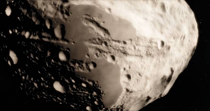
A bunch of problems can be seen. The major problem is a hole at zero (or 180?) meridian. I guess this is a 0 elevation border.
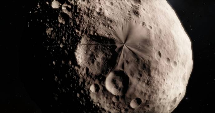
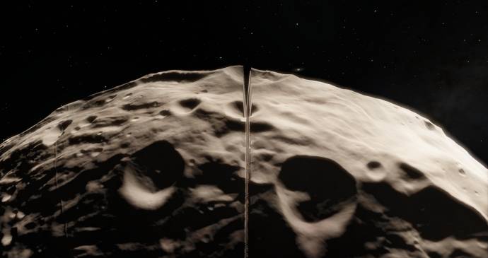
Filled crates near the pole:
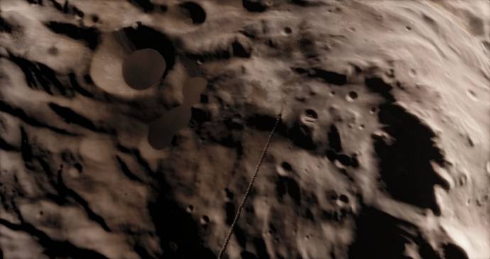
Small discontinues at some other meridian:
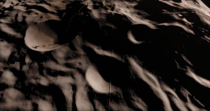
Cut mountains again. Not sure is this is your error or error in my cubemap utility. It's hard to inspect 16 bit images in graphics editor.

|
| |
| |
| 36ophiuchi | Date: Wednesday, 15.04.2015, 18:56 | Message # 36 |
|
Space Tourist
Group: Users
 Pirate
Messages: 26
Status: Offline
| Quote SpaceEngineer (  ) Cut mountains again. Not sure is this is your error or error in my cubemap utility. It's hard to inspect 16 bit images in graphics editor.
That is truly puzzling. In the previous iteration the cut-off mountains and filled craters occurred due to a processing parameter I had set incorrectly (cutting off 5% of the spectrum on both ends). I corrected that, checked the new product out, and it looked fine in 2D view (using qview). I am clueless. Is it by any means possible you accidentally used the older file again?
As for the seams: I'mended those few I was able to see, but they can be really elusive plain 2D-view.
The polar distortion: Maybe JohnVV has some advice?
|
| |
| |
| JohnVV | Date: Wednesday, 15.04.2015, 20:58 | Message # 37 |
|
Space Tourist
Group: Users
 United States
Messages: 36
Status: Offline
| i fine the BEST way to look for where errors are on a 16 bit signed or unsigned image is to do a very quick "Emboss" on it
like this NORMALIZED 1,65536 16 bit image of Vesta's northpole

the 16 bit image and a 8 bit "emboss"
full res emboss

a "shade" example using the height data ( sun at 270Deg long. and 45 deg asm.

Added (15.04.2015, 20:58)
---------------------------------------------
as to the polar "pinch"
a few things can cause it
bad original images
-- the above is the released scientific accurate DEM
-- GASKELL_CLAUDIA_2013_02_13 a 48 PPD image
the other is using "Cubic convolution " in resizing
this adds a " halo " artifact to the data
so when reducing a 17,281 x 8,641 PX image to say a 2880x1440 image
this can add artifacts near the pole
I tend to make 3 images , then resize them , then remap and recombine
( a lot of work )
1) remap the 48 ppd gaskel map to
90N to 60N polarsteriographic
the normal simple cylindrical
60S to 90S polarsteriographic
2) resize all 3 to 8 ppd (2880x1440)
3) remap the north and south pole bask to simple cylindrical
4) merge the 3 images into one
this can be dropped to 2 images
1) 90 north to 10 south polarsteriographic
2) 10 North to 90 South polarsteriographic
resize the two
remap the two a
join the two
Edited by JohnVV - Wednesday, 15.04.2015, 21:01 |
| |
| |
| SpaceEngineer | Date: Thursday, 16.04.2015, 20:08 | Message # 38 |
 Author of Space Engine
Group: Administrators
 Russian Federation
Messages: 4800
Status: Offline
| Maybe somewhere exist the maps for northern and southern polar region? I'm not familiar with GIS software, but it could be possible to create a six quadrilateralized spherical cube projections (aka cubemap) using regular GIS software and a polar regions maps. This will minimize the conversion artefacts. These cubeface maps can be used in SE's CubeMap utility directly - you just drop the first conversion stage (cylindrical to cube).

|
| |
| |
|
|
| JohnVV | Date: Wednesday, 30.09.2015, 05:29 | Message # 41 |
|
Space Tourist
Group: Users
 United States
Messages: 36
Status: Offline
| a bit back on the "other space sim" site i posted a bunch of obj shape files
The real data for the LOW RESOLUTION shapes
-- i still have a folder of 24 more meshes to add to the below link
http://forum.celestialmatters.org/viewtopic.php?f=4&t=636
now the only issue is i use simple cylindrical mapping and the meshes are UV mapped to that, and not to a cubemap . This is however rather fixable in Blender
the obj files can be uv mapped to a cubemap
the same for the hi resolution data like Vesta
http://forum.celestialmatters.org/viewtopic.php?f=4&t=682
or Ceres ( soon to be out dated )
http://forum.celestialmatters.org/viewtopic.php?f=4&t=741
-- see the UMSF web site Dawn ceres HAMO thread for my 3d renderings
or Dione
http://forum.celestialmatters.org/viewtopic.php?f=4&t=770
everything i posted on the links above are under cc-by-sa
credit=jpl/nasa/JohnVV/???
Edited by JohnVV - Wednesday, 30.09.2015, 05:32 |
| |
| |
| SpaceEngineer | Date: Wednesday, 30.09.2015, 22:33 | Message # 42 |
 Author of Space Engine
Group: Administrators
 Russian Federation
Messages: 4800
Status: Offline
| Cylindrical map can be converted to cubemap with SE utility, however for such low-res models quality is not good. SE terrain renderer also have seams on edges of the cube faces. I will implement a custom mesh-based shape for small bodies - it will be used as base shape for procedural terrain refinement.

|
| |
| |
| jjliang | Date: Friday, 02.10.2015, 03:23 | Message # 43 |
|
Space Tourist
Group: Users
 United States
Messages: 20
Status: Offline
| Shouldn't Uranus be colder than Neptune, despite Neptune being further away from the Sun? Uranus' surface temperature is -228 C, while Neptune's surface temperature is -224 C. Also, some asteroids, comets, and dwarf planets are the wrong size (it's extremely noticeable when using planet chart mode). For example, Pluto should be larger than Eris, Haumea should be smaller than Makemake, and Makemake should be smaller than Sedna. A list of how big objects in our Solar System can be found here.
Incorrectly labeled as a goof: in Space Engine v.0971. Makemake is colored dark red like this illustration, but in v.0972, Makemake is a pinkish-gray color... ...until you see this diagram showing the dwarf planet's actual relative sizes and colors (Makemake is at the bottom center), implying that this is the color Makemake really is in real life.
|
| |
| |
| steeljaw354 | Date: Sunday, 29.11.2015, 17:11 | Message # 44 |
 World Builder
Group: Users
 Pirate
Messages: 862
Status: Offline
| The pluto system needs to be updated since we have gotten pics of it from new horizons.
Ceres/Vesta need to have real surface textures not procuderal ones.
Sunspots should be visible on all stars but brown dwarfs.
Would like to see rouge planets
Planets around black holes
Add y dwarf star class
Add more new exoplanets
These are my suggestions for the future.
|
| |
| |
| JohnVV | Date: Sunday, 29.11.2015, 17:34 | Message # 45 |
|
Space Tourist
Group: Users
 United States
Messages: 36
Status: Offline
| Quote
The pluto system needs to be updated since we have gotten pics of it from new horizons.
Ceres/Vesta need to have real surface textures not procuderal ones.
1) Pluto
the pluto data is ONLY!!! crappy jpg's right now.
The data has NOT been released to the PDS archive for general use YET!!!
That will happen in about 6 to 12 months .
2) Ceres
Only the early r3 data is in PDS at this time
while this can be used to improve the existing DEM and 3d mesh -- not by much
the HAMO and LAMO data will be WAY BETTER
the Dawn Spacecraft is currently finishing it's HAMO orbits
|
| |
| |